
Hometown Evaluation:
Fort Lauderdale, Florida
(Old Postcard of Fort Lauderdale Beach.)
I grew up in Fort Lauderdale, Florida, a city about 40 minutes north of Miami. Contrary to popular belief, there are people living in South Florida under the age of 65. Anyways, my house was a five-minute drive from the beach, and the only time I traded my swimsuit for a snow suit was during Ski Week, a break our school had so we could experience other climates. Even though Fort Lauderdale is a very urbanized area, the kids are still FloGrown: learning to swim at the same age most kids are just learning to walk, having a boater’s license before a driver's license, and learning to catch and fillet fish while most kids are still using an easy bake oven. These traits are due to the close proximity people in South Florida have to the ocean and canals. The canal system in Fort Lauderdale is extensive which has led to the city being dubbed “The Venice of the United States.” South Florida was not always the urban, coastal paradise that I grew up in. In this article, I will provide an overview of what South Florida was like before modern civilization, discuss how human habitation has changed the environment over time, and assess my hometown as it is today.
Florida’s Physical Geography
In order to understand how Florida got its unique wetlands and lakes, it is crucial to know about how Florida went through periods where it was submerged in water, and other periods when land was exposed, due to glacial melting (Smith). Even though the peninsula north of Lake Okeechobee has not been completely underwater since about 25 million years ago, the size of Florida has continued to change (“An Action Plan to Conserve the Native Plants of Florida”). In fact, thirteen to twenty thousand years ago, the peninsula was twice its present size! Most of Florida’s 7,800 lakes and wetlands were formed during the postglacial Holocene Period (“An Action Plan to Conserve the Native Plants of Florida”).
The wetlands of Florida refer to the swamps and everglades found in the state. The Everglades National Park was created to help conserve the precious ecosystem of the everglades, but unfortunately this protected area is only expected to get smaller and smaller for people to use the land. These wetlands contain many rare plants and animals that are exclusive to the area. It is important for them to be protected (Davis & Ogden 1997).
The South-East Florida coast is protected by a number of barrier islands. Florida has more barrier islands than any other state. Barrier Islands are formed when heaps of sand, soil, and shells are swept from ocean floor by massive storm waves (“Barrier Islands”). These barrier islands are natural in northern and central Florida, but have been altered in South Florida to protect the mainland, and are manmade coastal features (Finkl). It is possible that before humans came to Florida the barrier islands did not look how they do today. In addition, Prior to humans settling in South Florida, the sand did not look how it does today. In fact, mangrove swamps dominated low wave energy shorelines. South Florida’s iconic sandy beaches are a product of beach nourishment, where sand is replenished with foreign sand dredged from the floor of the ocean.
Florida’s climate is warm and humid because the gulf stream currents bring warm water to the peninsula (Scavia et al.). These warm currents make Florida an ideal habitat for tropical plant growth, as wells plants from the temperate region up north. According to the Southeast Environmental Research Program at Florida International University, “From an ecosystem perspective, several potential functional niches are currently unfilled by this species-poor faunal mix; feedback effects on plant community structure are possible, but have not yet been well documented” (“An Action Plan to Conserve the Native Plants of Florida”).
Early Inhabitants
Prior to being settled by Spanish explorers, Natives Americans called South Florida home. There is archeological evidence that aboriginal natives arrived over 4,000 years ago, and later the Tequesta Indians lived in South Florida (“History of Fort Lauderdale, Florida.”). There was a very large Tequesta village on the New River where the City of Fort Lauderdale is located today for over two thousand years (“TEQUESTA - KEYS.”). The Tequesta Indians relied on the ocean for most of their food, eating mostly fish, shellfish, and nuts (“The Tequesta of Biscayne Bay.”). Additionally, they made their tools from shark teeth and shells. Even though they were living in a large village, they still were living off the land and not significantly altering the environment.
European Colonization
In the 1500s came the European settlers. The first notable explorer was Juan Ponce de León in 1513, which is when written records about Florida began (“European Exploration and Colonization.” ). The Tequestas were initially not too fond of settlers, but eventually were won over by gifts of colored cloth, knives, and rum (“The Tequesta of Biscayne Bay.”). Not long after these settlers arrived, the Tequesta tribe in the area began to die out because of settlement battles, disease, and slavery. At this point, there was still little disruption of the South Florida environment. Roads were probably causing minimal habitat fragmentation and trees were being cleared for building.
In the late 1700s, people from the Bahamas became the first known white settlers, settling on the New River (Broward.org).
Fast forward to Florida becoming a territory of the United States in 1821, which is where the pace seems to pick up. Years later in 1893, a very prominent man arrives to the New River and opens a trading post called “Fort Lauderdale” (Kersey). His name was Frank Stranahan. It was at this time where the Florida East Coast Canal, now known as the Intracoastal Waterways, began to be surveyed and dredged in the Fort Lauderdale area (Broward.org).
Early Fort Lauderdale
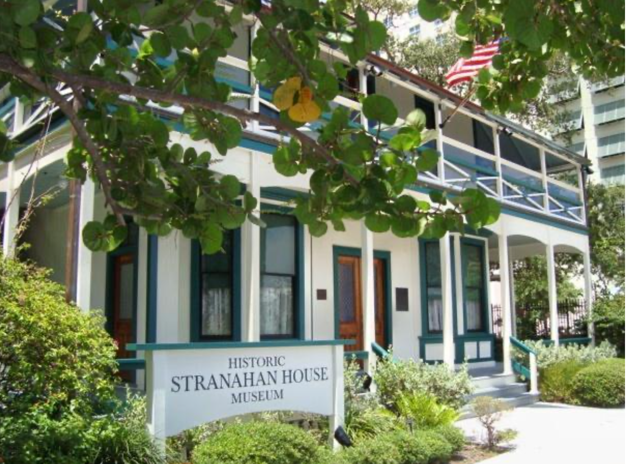
The Stranahan House
Frank Stranahan is an extremely significant person when discussing urbanization of South Florida. Without him, Fort Lauderdale would not have developed into the place it is today. He built a house that served as the first trading post, post office, bank, and hotel in the area. It all started when he moved from Ohio to South Florida to manage a ferry at Tarpon Bend on the New River at age 27 in January of 1893 (Kersey). He was able to quickly start a trading business with the Seminole Indians who lived upstream and regarded him as a fair businessman. Large groups of Seminole families would arrive in dugout canoes and camp at the post for days at a time. Frank knew he needed more space and eventually acquired 10 more acres along the river (“Stranahan House History”).
(Image by Julia Paige.)

Old Fort Lauderdale Village
The New River community continued to grow. In 1896, the Florida East Coast Railway was completed to Miami, which opened up South Florida for development.
(Image by Julia Paige.)
I went down to the Historical Center of Fort Lauderdale and spoke with Samantha Jalowski about how the railroad influenced the development of Fort Lauderdale. She explained that Florida basically developed bottom up and top down, leaving the space in the middle generally undeveloped. Fort Lauderdale was still swamp when Miami was prospering. The railroad was built so people could cross the New River and continue south toward Miami. It wasn’t until the introduction of this railroad that the Fort Lauderdale area began to be formally developed. Many of Broward’s early African American pioneers came as workers on the railway. Farming communities began to spring up near the railroad growing tomatoes, pineapples, and winter vegetables. The New River community was thriving and developing as exampled by a one room schoolhouse which was built on the property in 1899. In 1901, Frank built the present day Stranahan House, whose first floor served as a trading post and upper floor as a community hall (“Stranahan House History”). This building still stands today and is the oldest standing structure in Broward County (pictured below).

Railroad crossing New River
The railroad tracks going over the New River.
(Image by Julia Paige.)
At this point, Fort Lauderdale was not getting very much national or state wide attention. It was not until 1906 when Governor Napoleon Bonaparte began his project to drain the Everglades with the North New River Canal (“Five Hundred Years of Discovering Florida : Dredging and Drainage · USF Library Special & Digital Collections Exhibits.”). There was still a national push for expansion, and Bonaparte promised to create the “Empire of the Everglade.” This project was, and still is, detrimental to the natural ecosystem of South Florida. The project was filled with blatant errors due to the lack of understand of the geography and ecology of the Everglades. Most significantly, the Everglades are part of a massive watershed, which begins near Orlando and drains into Lake Okeechobee. Draining the Everglades has major effects on drinking water and agriculture in the immediate area, but also affects ecosystems north of Fort Lauderdale near Orlando. More recent projects in the Everglades continue to destroy habitats.
The Everglades project set precedent for more destruction of the environment in the area. Idlewyld, which is one of the first islands off Las Olas Boulevard in Fort Lauderdale was developed in 1919 from a reclaimed mangrove swamp (“History of Fort Lauderdale, Florida.”). In 1922, finger islands start to be dredged off Las Olas Boulevard to create the Venice subdivisions with all waterfront properties.
At this point, Fort Lauderdale began to boom. The City went through many governmental changes and social ones that were typical to most American cities at the time. This included segregation, desegregation, issues with war drafts, and stigma about immigrants.
An interesting factoid is how Fort Lauderdale became known as a spring break destination. In 1935, the Las Olas Casino Pool hosted the first Collegiate Aquatic Swim Forum. These swimmers returned to their campuses raving about Fort Lauderdale. This is considered by many people to be the origins of the annual “Spring Break” phenomenon (Broward.org).
Fort Lauderdale Today
Today, according to the 2010 Census, Fort Lauderdale has a population of 165,521 people. It is part of the Miami metro area which has a population of 6,012,331. In the Fort Lauderdale area, 52.5% of people are Caucasian, not including white Hispanics, 31% are black, 13.7% are Hispanic or Latino, 1.5% are Asian, and 0.3 are native American. 2.1% of people say they are two or more races, and there are 2.4% of people who are of another race (“History of Fort Lauderdale, Florida.”).
In this section, a fifteen-minute radius of the downtown area of Fort Lauderdale will be discussed.
I called my grandma who has been living in Fort Lauderdale for about 50 years for some insight about the city’s layout and street patterns. After asking me if I was lost and asking for directions, she said: “It’s a grid. Broward and Andrews are ‘0.0’, everything from there is either north, east, south, or west” (Jessica). Within this street grid are neighborhoods, shops, restaurants, parks and other shared spaces that help the city function.

Panoramic photo of the New River and Fort Lauderdale
(Image by Julia Paige.)
Fort Lauderdale is coastal, and many residents spend quite a lot of time at the beach. Even though Fort Lauderdale is urban, there are a lot of parks. Birch State Park which even has a tunnel that walks through to the beach. The park, which is between the intracoastal and the Atlantic Ocean, has a few hiking trails and tons of wildlife.
The city has a lot to offer on the shopping and entertainment fronts. The City is served by the Broward Center for the Performing Arts, the Parker Playhouse, the Museum of Discovery and Science, the Las Olas Shopping District, and the Galleria Mall.
Any resident of this part of Fort Lauderdale can easily get to a commercial area just by a quick walk. The Las Olas area is made up of a series of canals so most of the properties are waterfront. The neighborhoods are located on mostly singular roads that branch off from Las Olas Boulevard.

Aerial photo from Google Maps of Las Olas, marked by State Road 842.
This is a wealthier area of the city, and the homes reflect that. All of the homes have seen have shared spaces and backyards. A number of these homes have pools. There is a typical layout of several South Florida homes. In this layout, bedrooms are toward the edges of the property bordering the neighbors, the living room or family room is on the side of the house where the street is, and the kitchen and other shared spaces look over the backyard. In addition, almost every home in Fort Lauderdale has air conditioning. This area can get extremely hot and humid, and air conditioning makes living here much more bearable.
The Future of Fort Lauderdale
Fort Lauderdale respects it history, and protects its historic buildings. In terms of land use, imprints on the land include the total lack of swamps in the area. For a city that used to be considered unlivable due to being swamped out, it sure feels livable. More commercial areas and apartment buildings are currently being developed. In the near future, expect to see a higher percentage of people living in apartments instead of single family homes. In the still near, but further future, picture something much more upsetting. It is predicted that in 100 years, it is possible that South Florida may be under water due to sea level rise from global warming (Church).
For a city that could be submerged in water in the next 100 years, citizens are not aware of many environmental or sustainability issues. It comes as a shock that such an at-risk group knows so little. The City itself is trying to promote sustainable growth of the city. The city strives to be a sustainable and climate-resilient community and have a Department of Sustainable Development, along with a Sustainability Action Plan (SAP) (“Sustainability Action Plan.”). This plan stresses that natural resources need to be protected. On the website's homepage, there is a pretty heavy statement that “reducing our impact on the environment are essential to our economic prosperity, our neighbors’ health and to the very social fabric of our City” (“Sustainability Action Plan.”). SAP has four divisions: Sustainability and Climate Resilience, Environmental and Regulatory Affairs, Solid Waste and Recycling, and Fleet Service. Eight areas are suggested in SAP to work on: leadership, air quality, energy, water, build and natural environment, transportation, waste, and progress tracking. The plan notes specific changes that should be made to make a more sustainable city including the addition of 5,000 linear feet of bike lanes, greenways, shared use paths, and sidewalks (Torriente). The city is also encouraging people to switch to more efficient cars and use less water. The city has far too many goals to mention here, but look to be on the right track.
Since Florida was developed top down and bottom up, Fort Lauderdale was basically the last part of the state to be developed. Compared to the development of other cities in the United States, Fort Lauderdale has a fairly recent history. It is important to learn the history of your hometown. It appears that my hometown is making efforts to become more sustainable, which I hope continues. It is crucial for the survival of my hometown that people acknowledge climate change and alter their habits before it is too late.
References
(n.d.). Retrieved June 20, 2017, from https://fcit.usf.edu/florida/lessons/tequest/tequest1.htm
Old Fort Lauderdale Village [Personal photograph taken in Fort Lauderdale]. (2017, June 10).
Railroad Crossing New River [Personal photograph taken in Fort Lauderdale, FL]. (2017, June 10).
Fort Lauderdale Skyline [Personal photograph taken in Fort Lauderdale, FL]. (2017, June 10).
(n.d.). Retrieved July 03, 2017, from https://www.google.com/maps/place/FortLauderdale, FL/@26.1409985,- 80.2200133,12z/data=!3m1!4b1!4m5!3m4!1s0x88d9012720facaf5:0x7602be7540 bf8ebe!8m2!3d26.1224386!4d-80.1373174
An Action Plan to Conserve the Native Plants of Florida. (n.d.). Retrieved June 20, 2017, from http://everglades.fiu.edu/serp/action/patterns.html
Barrier Islands. (2009). Retrieved June 20, 2017, from http://www.pbchistoryonline.org/page/barrier-islands
Betty Whatley Cobb and Susan Gillis. (2015). Broward.org [Brochure]. Fort Lauderdale, FL: Author. Retrieved June 20, 2017, from http://digitalarchives.broward.org/ui/custom/default/collection/default/resources/cu stompages/collectionsatoz/BCL_HistoricalBrochureADA.pdf
Church, J. A., & White, N. J. (2006). A 20th century acceleration in global sea-level rise. Geophysical Research Letters, 33(1). doi:10.1029/2005gl024826
Davis, S. M., & Ogden, J. C. (1997). Everglades: the ecosystem and its restoration. Boca Raton, Fla: St. Lucie Press.
European Exploration and Colonization. (n.d.). Retrieved June 20, 2017, from http://dos.myflorida.com/florida-facts/florida-history/a-brief-history/european- exploration-and-colonization/
Finkl, C. W. (n.d.). East Florida's Barrier Islands: Natural vs. Man-Made; By Dr. Charles W. Finkl. Retrieved June 20, 2017, from http://coastalcare.org/2014/02/east- floridas-barrier-islands-natural-vs-man-made/
Five Hundred Years of Discovering Florida : Dredging and Drainage · USF Library Special & Digital Collections Exhibits. (n.d.). Retrieved June 20, 2017, from http://exhibits.lib.usf.edu/exhibits/show/discovering-florida/technology/dredging- and-drainage
FortLauderdale.gov. (n.d.). Retrieved June 20, 2017, from http://www.fortlauderdale.gov/departments/sustainable-development/economic- development/demographics-location-highlights
History of Fort Lauderdale, Florida. (2017, June 15). Retrieved June 20, 2017, from https://en.wikipedia.org/wiki/History_of_Fort_Lauderdale,_Florida#cite_note- coastal-6
Jalowski, S. (2017, June 18). Interview with Samantha Jalowski [Personal interview].
Kersey, H. A. (2003). The Stranahans of Fort Lauderdale a pioneer family of New River (4th ed., Vol. 83, Spring, 2005). Gainesville, FL: University Press of Florida. Loveless, C. M. (1959). A Study of the Vegetation in the Florida Everglades. Ecology, 40(1), 1-9. doi:10.2307/1929916
Old Postcard of Fort Lauderdale Beach [Photograph found in Fort Lauderdale]. (n.d.).Retrieved June 29, 2017, from https://farm8.staticflickr.com/7117/7745725058_74d67841b6_b.jpg
J. (2017, June 19). Interview with Jessica [Telephone interview].
Scavia, D., Field, J. C., Boesch, D. F., Buddemeier, R. W., Burkett, V., Cayan, D. R., ... Titus, J. G. (2002). Climate change impacts on U.S. Coastal and Marine Ecosystems. Estuaries, 25(2), 149-164. DOI: 10.1007/BF02691304
Smith, J. R. (1930). Human Geography: Regions and trade. Philadelphia: John C. Winston Co.
Stranahan House [Photograph found in Fort Lauderdale]. (n.d.). Retrieved June 28, 2017, from http://www.stranahanhouse.org/about/history Stranahan House History. (n.d.). Retrieved June 20, 2017, from http://www.stranahanhouse.org/about/history
Sustainability Action Plan. (n.d.). Retrieved June 20, 2017, from http://gyr.fortlauderdale.gov/greener-government/sustainability-action-plan
TEQUESTA - KEYS. (n.d.). Retrieved June 20, 2017, from http://www.losttribesflorida.com/tequesta---keys.html
The Tequesta of Biscayne Bay. (n.d.). Retrieved June 21, 2017, from https://fcit.usf.edu/florida/lessons/tequest/tequest1.htm
Torriente, S. M. (n.d.). City of Fort Lauderdale Sustainability Action Plan. Retrieved from http://gyr.fortlauderdale.gov/home/showdocument?id=9892